7 Fabulous Fall Roadtrips
 Fall, leaves, fall; die, flowers, away;
    Lengthen night and shorten day;
    Every leaf speaks bliss to me
    Fluttering from the autumn tree.
                -Emily Bronte
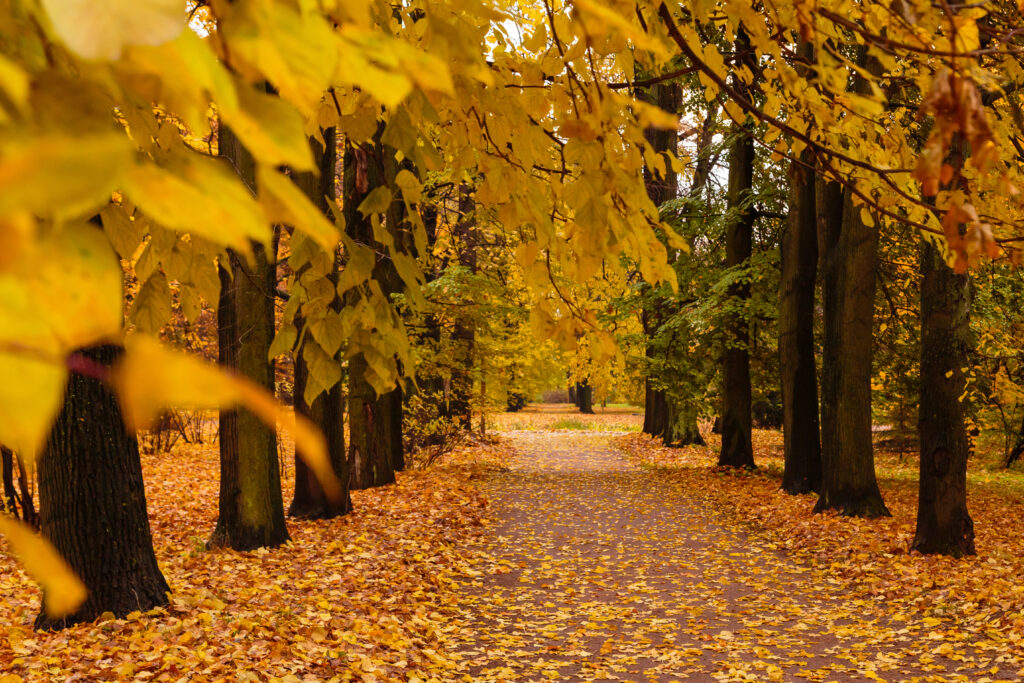
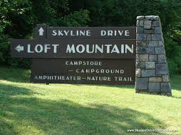
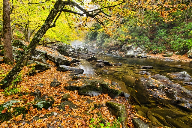
Skyline Drive, Virginia
The Shenandoah National Forest stretches for 105 miles along the western side of Virginia. Skyline Drive, the main north-to-south route through the forest, passes over the Blue Ridge mountains from Fort Royal, Virginia to Waynesboro, Virginia.
The drive is beautiful any time of the year as it winds through the densely wooded park. When the trees change color in the fall, though, it is breathtaking. Shades of rust, brown, pink, red, yellow, gold, and green dot the landscape like an artist’s palette.
Skyline Drive twists along the top of the Blue Ridge. Over 50 scenic overlooks provide ample opportunity to pull over and take in the big picture. Keep your camera handy because there is plenty of wildlife hidden along the way.
The speed limit along the entire roadway is 35 miles per hour for safety’s sake, but you might choose to travel at a slower pace so you don’t miss anything. Also, while the snakey road does not have posted vehicle limits, it will be necessary to shift to a lower gear on the steep inclines. Another important thing to know is the tunnel clearance at mile marker 32 is only 12′ 8″.
If you travel from north to south at the recommended speed limit, the whole trip will take about four hours if you don’t stop, but there are plenty of things worth seeing along the journey.
Waterfalls are common along the route. Hiking trails provide access to some of the most picturesque waterfalls hidden deep in the forest. Dark Hollow Falls Trail is the shortest trail in the park but is also quite steep and challenging. The Jones Run Falls trailhead is less challenging, but a fairly long hike.
Other must-see attractions along Skyline Drive include Skyland Resort. Guests can stay in the iconic inn, which was built in the 1890s and offers rooms and cabins from April through November.
The Byrd Visitor Center features exhibits that tell the history of the area and is located close to Hawksbill Mountain, the highest point in the park. The view from atop this rocky hilltop is worth the stop.
If you want to start your journey bright and early one morning, there is a campground at each end of Skyline Drive. Mathews Arm Campground is to the north, close to Rileyville, while Loft Mountain Campground, near Crozet, is at the south end of the trail. Either location is an excellent launching point for your adventure.
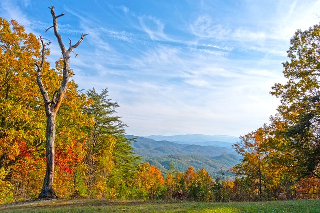
Great Smoky Mountains
**NOTE: On September 26-27, 2024, Hurricane Helene caused massive destruction and loss of life in Western North Carolina and Eastern Tennessee. Portions of Interstates 40 and 26 are closed indefinitely, and some attractions mentioned here may no longer be accessible. Please avoid travel in this area until the Federal Government reopens the roads and clears the area for tourism.
The busiest fall leaf sighting drive in the United States is undeniably the trip through the Great Smoky Mountains National Park of North Carolina and Tennessee. Peak fall color viewing takes place in October as over 1000 varieties of plant life prepare for winter.
On most days, a hazy fog covers the higher elevations of the park. Natural gases released by the trees cause this ‘smoke’. Pollution, introduced to the area in the last hundred years, has tainted the air and increased the smoke-like appearance that hangs over the mountaintops.
The immense size of the park makes it impossible to explore the entire area in one weekend, but breaking it down over three or four days allows visitors to see all the major highlights. Multiple campgrounds and motels provide lodging throughout the park.
One attraction worth the trip is Clingman’s Dome, the highest point in Tennessee. The mountain sits on the North Carolina-Tennessee state line and offers a bird’s-eye view of seven states: Tennessee, South Carolina, Georgia, Alabama, North Carolina, Kentucky, and Virginia. To reach the dome, visitors park in a paved lot and climb a curved ramp that leads to the top.
Not far from Clingman’s Dome is the Mountain Farm Museum at Oconaluftee. Here, costumed park employees offer the history of the park and perform pioneer activities such as milling corn, churning butter, and working with horse-drawn implements for farming.
Nature lovers and photographers enjoy the Cades Cove Loop in the Tennessee portion of the park. This 11-mile, one-way road is the site of a now abandoned pioneer community founded in the 1820s. The small community survived until the 1920s, but most people moved out after the government purchased the land for the creation of Great Smoky Mountains Park. Today, the park service has preserved the area much as it was then.
This is just a small introduction to the many attractions, hiking trails, historical landmarks, and natural areas located within the Great Smoky Mountains National Park.
Ozark National Scenic Riverways Park
The Ozark National Scenic Riverways Park passes through the state of Missouri along Highway 60. State parks and scenic waterways line both sides of this curvy highway.
One highlight of the route is the Current River. This recreational river is a favorite with kayakers, canoeists, and rafters. Anglers enjoy catching a variety of fish species in the clear, cold water.
Several outfitters offer float trips down the wide, shallow water trail. Campgrounds and cabins are located along the riverbanks and in the nearby town of Van Buren.
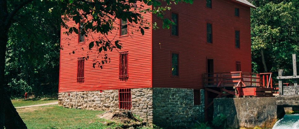
One of the best places to see fall foliage along this route is along Highway 19, which leads to the tiny town of Eminence. This charming village offers restaurants, specialty shops, hotels, a lodge, and several riverfront campgrounds. The Alley Springs Grist Mill, circa 1894, offers a look into the past.
Further west on Highway 60, just past the town of Bartlett, is the Birch Creek Conservation Area. This preserved wilderness park is a great place for bird-watching or spending some quiet time surrounded by nature.
Continuing to travel west will take you through the small towns of Cabool and Mountain Grove as you travel toward the city of Springfield, home of many attractions, museums, and shopping establishments.
Pig Trail Scenic Highway
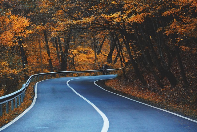
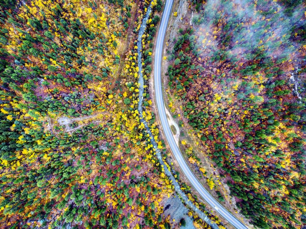
If you are looking for scenic byways off the beaten path, Pig Trail Scenic Highway is one you don’t want to miss. Officially, the road is Highway 23, but locals call it Pig Trail Highway. This 19-mile road begins near Brashears, Arkansas, and travels south to Interstate 40 near White Oak.
The Pig Trail is a two-lane highway that twists and turns through the Ozark mountains, over the Mulberry River. The numerous switchbacks make this a favorite route for motorcyclists in the spring and fall.
Trees line both sides of the narrow roadway, and the roadsides erupt in color during late September and early October. Not only is the Pig Trail Scenic Highway one of the best places to see fall foliage, but many other sights line the route.
The Pig Trail Waterfall has an 18-foot drop and is located directly off the shoulder of the road, near Mulberry Bridge. It is possible to see this fall from your car, but it is also a great place to stretch your legs and take a photo or two.
The Cherry Bend Recreation Center offers information about the area and a challenging hiking trail to Murray Falls and Senyard Falls. These two falls are close enough that they often look connected during extreme water flow. They describe the hike as moderate, but they do not maintain the trail well.
RV parks and cabin rentals are numerous along Pig Trail Highway and offer a range of amenities and prices. The area is a favorite for tourists and vacationers, so plan your trip early.
Daniel Boone National Forest
One of the prettiest drives in the country goes right through the heart of Kentucky. This wilderness in the Bluegrass state is the best way to experience the fall in Kentucky.
The park features more than 600 miles of hiking trails across all types of terrain. The thickly forested area is named after explorer and frontiersman Daniel Boone, who called the place the land of Eden.
There is not a single route that crosses the entire forest, but leaf peepers will enjoy the drive along Highway 25 from Pittsburg to Mt. Vernon. This curvy, scenic route passes through some of the most beautiful rural farmland in the state.
An alternate route takes travelers along Highway 192 from Somerset to Pittsburg. This is also a rural route through farmland and natural areas.
While traveling through the forest, visitors often spend a day at one of the many lakes in the area. Laurel River Lake in the Beaver Creek Wilderness Zone offers excellent fishing any time of the year. Cave Run Lake, the largest in the Daniel Boone National Forest, is easily accessed via Interstate 64 or Highway 460.
Due to its central location, Daniel Boone National Forest is close to the metropolises of Lexington and Louisville. These large cities offer museums, attractions, nightlife, and shopping experiences. Distillery tours are a popular activity for visitors to the region.

Nature lovers appreciate the forest’s close proximity to Mammoth Cave National Park. In addition to touring the longest cave system in the world, visitors can kayak the Green and Nolin Rivers, hike miles of trails, and view wildlife at the zoo. Nearby Red River Gorge is another favorite of hikers and kayakers.
Dining, hotels, and RV parks are numerous in the area, due to the high tourist influx surrounding Mammoth Cave, which is open year round.
Highway 14 through Spearfish Canyon
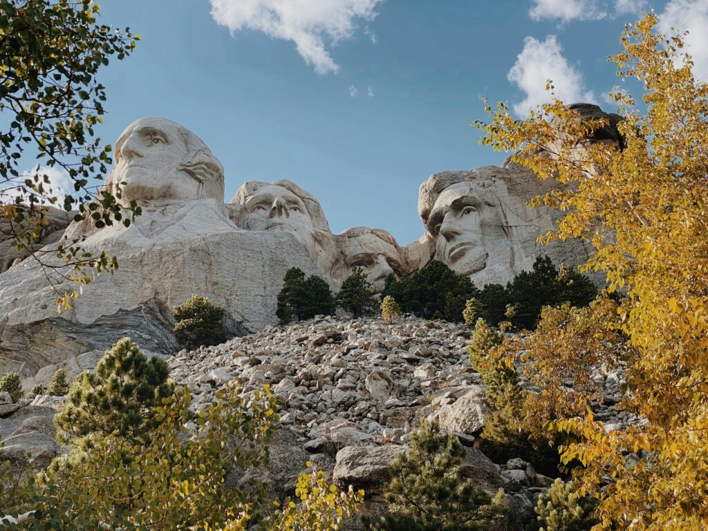
South Dakota is known for big presidents’ heads, Wall Drug, the Sturgis Biker Rally, and Badlands National Park, but the Mount Rushmore state is also a natural wonderland.
From the sandstone mesas to the temperature grasslands, South Dakota has a wide range of natural biomes. Grassy plains in the east give way to forested hills in the west part of the state. These Black Hills house thousands of varieties of plant life, including deciduous and evergreen trees. It is this variety that provides the wonderful fall colors only South Dakota can bring.
While any location on the mountainous western side of the state provides an opportunity for nature viewing, there is one roadway that even the locals prefer for its scenic overlooks and roadside waterfalls. That road is Highway 14A, a narrow, twisty two-lane that passes through the steep canyon walls from Lead, SD to Spearfish, SD.
The scenic byway is a favorite of motorcyclists, who find the twists and turns exciting. Tourists traveling the area often travel the narrow road on their journey into or out of Mt. Rushmore National Memorial Park.
Besides Mt. Rushmore, there is plenty to do in the immediate area of Spearfish. Deadwood and Lead are both Old West towns and cowboys still have shootouts in the streets, even though they are paid actors. Gold and gem panning and museums dedicated to the gold rush in the area are common.
Bridal Veil Falls and Lookout Mountain are popular with hikers. Native Americans are recognized at the Tatanka Exhibit, the High Plains Western Heritage Center, and the Crazy Horse Memorial.
Although food and lodging along Highway 14 is sparse, the drive is only 20 miles and takes just a few hours without stops. The nearby towns of Spearfish, Sturgis, and Deadwood offer restaurants, motels, and camping in state parks and private RV resorts.
The best time to visit this area to view fall foliage is the month of September. Snowfall has occurred in late September and early October, historically.
Natchez Trace Parkway, TN
The Natchez Trace is a 444 mile path that begins near Nashville, TN and ends near Natchez, MS. The historic route served settlers, soldiers, and traders in the 1700s and 1800s. Today, the Natchez Trace is traveled by tourists, history buffs, and nature lovers.
In Tennessee, the Natchez Trace runs in a diagonal line that loosely parallels Interstate 40. While the interstate offers faster travel, it offers none of the history and beauty offered by the Trace. Historic sites, waterfalls, wildlife viewing areas, and hiking trails are numerous along the scenic route, but you won’t find any fast food or hotels.
In order to preserve the historical significance and beauty the Natchez Trace offers, all commercial establishments must be located on roads adjacent to the Trace in one of the many small towns along the way.
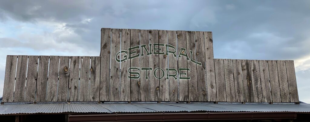
Don’t worry about a lack of food, though. Some of the areas best small town diners and country stores are located along the way. Don’t discount the idea of a fried bologna sandwich from the general store until you’ve had one. If you must have a taco or burger, however, there are plenty of commercial eateries along Highways 412 and 64, along with Interstate 40.
American history enthusiasts will enjoy the drive along the Natchez Trace, which follows the route soldiers traveled during the Civil War. Numerous historical markers and historic building remains tell the story of the war-torn south.
Meriwether Lewis’s gravesite, the War of 1812 memorial, and Captain John Gordon’s house are popular stopping points for history lovers. Other points of interest are markers for the Trail of Tears, the Old Tobacco Barn, and the Shebosh Inn.
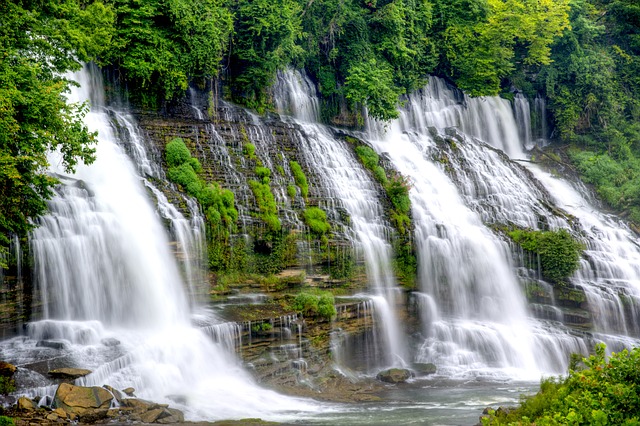
Nature lovers will enjoy the hundreds of miles of hiking trails, many of which end at waterfalls. Tennessee has more than 900 waterfalls and many of those are visible from locations along the Natchez Trace Parkway.
Camping is plentiful along the Trace. There are three park service maintained campgrounds, but they do not offer electric, water, or sewer hookups. Hohenwald, TN offers two nice privately owned campgrounds, and there are several in the Franklin, TN area. Loretta Lynn’s Campground and historic home site, in nearby Waverly, TN is a great side trip.